



























The World Meteorological Organisation (WMO) has warned that El Nino has developed in the tropical Pacific and is likely to strengthen significantly over the next few months.
In a statement released on Friday, the United Nations weather agency said sea surface temperatures in the central and eastern equatorial Pacific are expected to rise further, with temperatures in key monitoring regions likely to exceed 2 degree Celsius above average between July and September 2026.
The agency said the climate pattern is expected to evolve into a strong El Nino event during this period.
Global ocean temperatures hit a record high for June, according to the latest Copernicus Climate Change Service & @CMEMS_EU data.
Over the past three years, oceans outside the polar regions have been 0.35–0.73°C warmer than average. El Niño pushed June to a new record. pic.twitter.com/GikJ0IT9CN— World Meteorological Organization (@WMO) July 2, 2026
Increased risk of extreme weather
WMO Secretary-General Celeste Saulo said the developing El Nino could lead to more intense weather events across several parts of the world.
Also Read | UNESCO issues big warning to Pakistan over 2 Taxila sites
“This will intensify the chances of drought and heavy rainfall and increase the risk of heatwaves on land and marine heatwaves in many regions of the world,” Saulo said.
The organisation said it has launched a coordinated effort involving governments, humanitarian agencies and climate-sensitive sectors such as agriculture and health to improve forecasts and strengthen early warning systems.
Regions likely to see changes
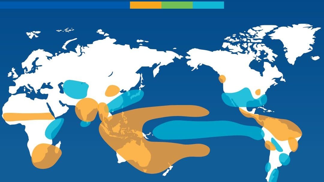
According to WMO forecasts, parts of the Indian subcontinent, much of Australia and sections of the tropical Indian Ocean could experience below-normal rainfall.
El Niño typically has a warming effect on global temperatures, with the strongest influence often felt in the year after it develops.
It typically brings wetter conditions to some regions and drought to others, though effects vary around the world.
More 👉 https://t.co/jMd3hGUX7x pic.twitter.com/ZDTJUE3YVx— World Meteorological Organization (@WMO) June 9, 2026
At the same time, above-normal rainfall is expected over the central and eastern equatorial Pacific and parts of the Gulf of Guinea in Africa.
The agency also warned of increased chances of reduced rainfall in the Greater Horn of Africa, parts of Central America, the Caribbean and northwestern South America.
Europe may see contrasting conditions, with wetter weather expected in southern regions and drier conditions likely in the north, although confidence in these projections remains lower.
Warmer-than-average ocean temperatures are also expected across the Indian Ocean and the tropical Atlantic.
What is El Nino?
El Nino is the warm phase of the El Nino-Southern Oscillation, a naturally occurring climate pattern linked to unusually warm sea surface temperatures in the central and eastern Pacific Ocean.
Also Read | Europe heatwave claims over 1,300 lives as temperatures soar across continent
The phenomenon usually develops every two to seven years and can last between nine and 12 months. It is considered one of the strongest influences on global climate patterns and can affect rainfall, temperatures and weather conditions in different parts of the world.
Its impacts vary depending on its strength and interactions with other climate systems.
FAQs:
What is El Nino?
El Nino is a climate pattern caused by unusually warm waters in the Pacific Ocean.
What weather impacts can El Nino cause?
It can increase the risk of heatwaves, droughts, heavy rainfall and changing weather patterns.